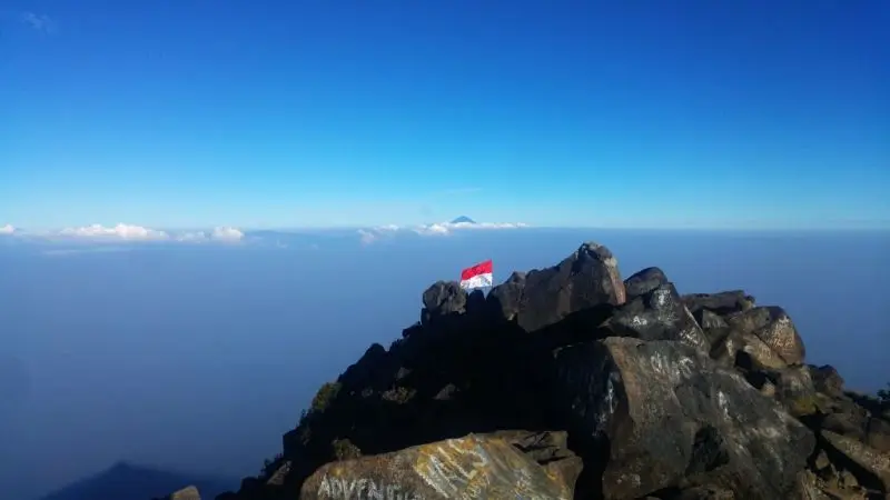
Why Arjuno and Welirang
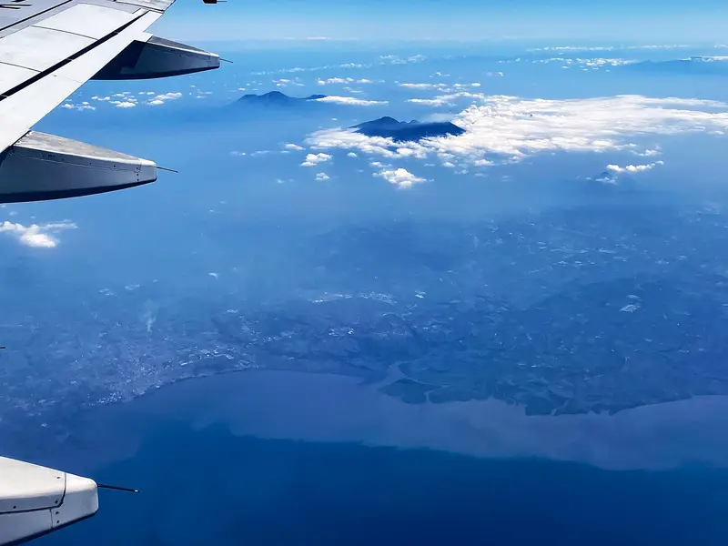
From the Surabaya–Malang toll road you see them without looking: a long blue silhouette with, at its northern end, a white plume. This is the Arjuno-Welirang massif, one of Java's best-kept secrets.
What you find there: a six-kilometre volcanic ridge linking two summits above 3,000 m; an old cobbled track down which Welirang's sulphur miners still descend; pine and casuarina forests, high savannahs where deer graze; and, on the south side, dozens of terraces, altars and Hindu-Buddhist temples from the Majapahit era, where Javanese pilgrims climb to meditate.
What you do not find: foreign crowds. At weekends Indonesian students camp by the hundred; on weekdays you can spend a whole day without meeting anyone. And from the summit of Arjuno the view takes in Semeru, Bromo, Argopuro, Penanggungan and, on clear days, Lawu 150 km to the west.
It is not a spectacular volcano the way Semeru is: no ash plume, no lava. It is a mountain you earn, travel and live over several days.
Arjuno-Welirang at a glance
| Elevations | Arjuno 3,339 m (Puncak Ogal-Agil); Welirang 3,156 m; the Kembar peaks in between |
|---|---|
| Type | Massif of andesitic stratovolcanoes; only Welirang is active |
| Activity | Fumaroles and solfataras in the Welirang crater; last eruptions in 1950-1952 |
| Manager | UPT Taman Hutan Raya (Tahura) Raden Soerjo |
| Main routes | Tretes (Pasuruan), Cangar – Sumber Brantas (Batu), Purwosari (Pasuruan), Lawang (Malang) |
| Time | Welirang: 2 days. Arjuno: 2 days. Both: 3 days |
| Ascent | Up to 2,400 m from Tretes; 1,400 m from Cangar |
| Difficulty | Sustained; navigation tricky between the two summits |
Is Arjuno-Welirang open?
The box next to this article gives today's status, with its source and date.
The volcano itself is calm: the PVMBG keeps it at level I (normal). The MAGMA report of 15 November 2026 only asks people not to camp at the Welirang crater and not to linger near the gas vents.
The massif's closures come from elsewhere: rain and, above all, fire. In 2026 the Tahura closed the routes from November 2025 to 7 May 2026 (rainy season), then partly in June–July, then after a fire on 19 August, and again since 17 October 2026 after forest fires, with no reopening date announced. Late dry-season fires return to this massif almost every year.
When to go
- May to August: the best period. Clear skies, dry trails, cold nights (0 to 5 °C at the camps).
- September–October: good weather but a risk of fire closure.
- November to April: rainy season, frequent closures, muddy trails and fog on the ridge.
- Avoid weekends and Indonesian public holidays: the camps are packed.
Booking and rules
- Online booking is compulsory with Tahura Raden Soerjo, through its app (SiPenerang).
- Entrance fee: 200,000 IDR (≈ 10 €) per day for a foreign visitor, the rate in force since the May 2026 reopening, valid for Arjuno, Welirang and Lincing hill.
- Registration at the trailhead post of your chosen route, with a copy of your passport.
- Forbidden: camping at the Welirang crater, lighting fires in the dry season, leaving rubbish, leaving the trails on the Purwosari route, where the sacred sites are.
Getting there
The massif lies between Surabaya (to the north), Malang (to the south-east) and Batu (to the south-west).
- Tretes (Prigen), to the north-east, is an old colonial-era hill station, 1 h 30 from Surabaya airport. A taxi costs about 300,000 IDR (≈ 15 €) from Surabaya, or 350,000 IDR (≈ 18 €) from Malang.
- Cangar and Sumber Brantas, to the south-west, are reached via Batu, 45 minutes from Malang.
- Purwosari and Lawang are on the main Surabaya – Malang road.
The routes
The Tretes route, the miners' route
This is the historic route, and the easiest to follow: a wide cobbled track built to bring Welirang's sulphur down, climbing straight from Tretes (about 800 m) to the miners' camp.
| Stage | Elevation | Time |
|---|---|---|
| Tretes → Pet Bocor (registration) | 800 → 970 m | 15 min |
| Pet Bocor → Kokopan (spring, shelter) | → 1,650 m | 3 h |
| Kokopan → Pondokan, the miners' camp | → 2,450 m | 3 to 4 h |
| Pondokan → Lembah Kijang, camp | → 2,485 m | 30 min |
| Lembah Kijang → Welirang summit | → 3,156 m | 3 h |
| Lembah Kijang → Arjuno summit, via the Kembar | → 3,339 m | 3 h |
The track has no technical difficulty, but the ascent is huge: nearly 2,400 m from Tretes to the summit. The six-hour descent on the cobbles is torture for the knees.
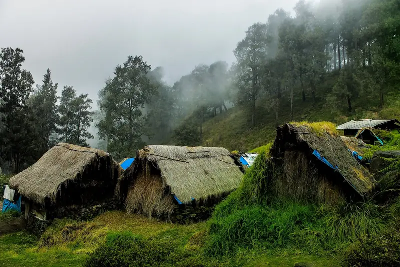
Pondokan is a hamlet of wooden and tarpaulin huts where Welirang's miners lived, and a few still live. Lembah Kijang, the "deer valley", is a grassy clearing a little further on, where you camp and often meet rusa deer at dawn.
To the summit of Welirang
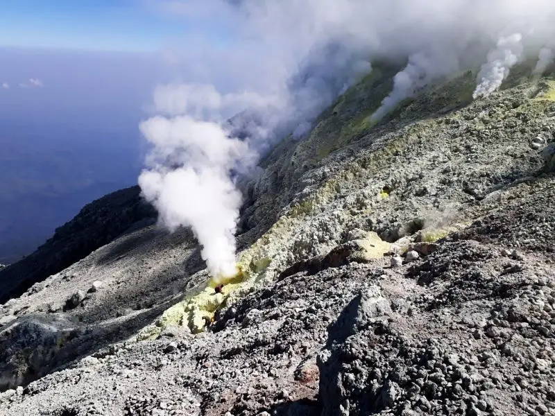
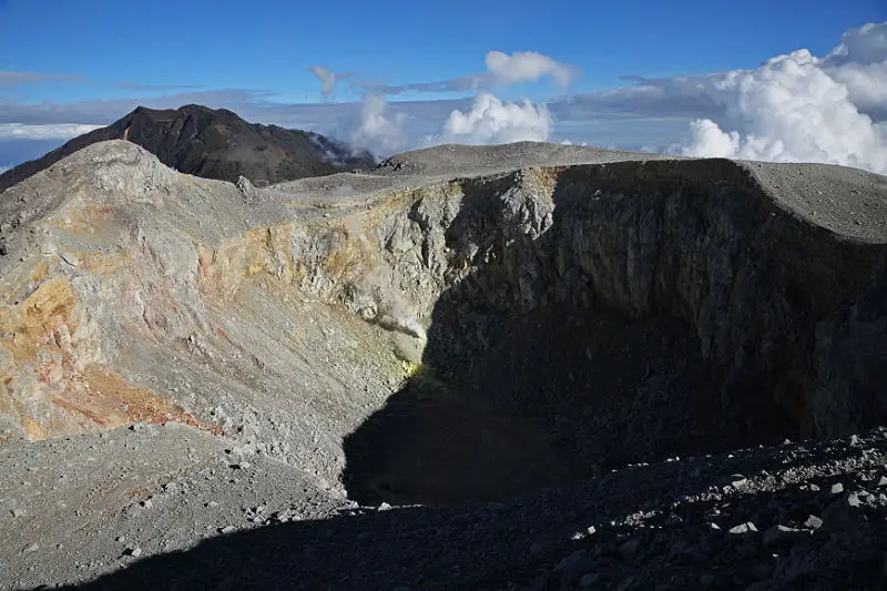
From Lembah Kijang you climb north to a 2,965 m pass, where the view opens onto Cangar and Mount Anjasmoro. You leave the miners' track on your left, lined with sacks of yellow sulphur, and tackle the cone. The summit overlooks the Kawah Jero crater, full of fumaroles and sulphur deposits. Going round the crater takes 30 minutes. On a clear day you can see from Lawu in the west to Raung in the east.
To the summit of Arjuno
Southwards, the trail crosses the two Kembar peaks (the "twins"), dotted with small grassy craters and sulphur vents, then drops into a chaos of volcanic boulders before climbing steeply to the summit of Arjuno, Puncak Ogal-Agil, a pile of balanced boulders. This is where people get lost most easily, especially in fog. A guide is strongly recommended.
The Cangar and Sumber Brantas route, the shortest
It starts at 1,750 m, just before the Cangar hot springs, and crosses potato and carrot fields before entering forest at around 2,000 m. Around 2,650 m, hot steam rises from rocks in the pine forest. The trail reaches the Kembar pass (2,910 m), from which you head for Welirang to the north or Arjuno to the south. It lets you do a summit in two days with much less ascent, and finish with a soak in the Cangar hot springs. The trails are unmarked and often cross: a guide is essential.
The Purwosari route, the temple route
North-east of Arjuno, the Purwosari (Tambaksari) route is a pilgrimage path. It climbs from sacred site to sacred site: Onto Boego, Tampuono, Eyang Sakri, Eyang Semar, Makutoromo, Sepilar, then the summit. These are terraces, altars and remains of temples from the Majapahit era (13th–15th centuries), where Javanese followers of kejawen still come to meditate and leave offerings. It is the longest and most fascinating route. It requires a guide who knows the places, and respect for the pilgrims.
The Lawang route
From the south-east, from Lawang, a forest route climbs towards Arjuno via the Lalijiwo savannah. Less used, it also requires a guide.
Map and GPX track
- Tretes → Kokopan → Pondokan → Welirang et ArjunoDistance 8.6 km · Elevation gain 1,924 m · Start 1,038 m → High point 2,993 mDownload the GPX track ↓
- Purwosari → sites sacrés → ArjunoDistance 6.2 km · Elevation gain 2,065 m · Start 1,215 m → High point 3,308 mDownload the GPX track ↓
Indicative route from OpenStreetMap; elevations from Copernicus. Check on the ground and follow your guide. © OpenStreetMap, OpenTopoMap (CC-BY-SA), Open-Meteo.
How much does the trek cost?
The entrance fee is 200,000 IDR (≈ 10 €) per day per person for a foreigner. Add transport to the trailhead, a guide (essential for Arjuno), porters and camping gear.
With Terre des Volcans, the two-day Welirang starts at 2,550,000 IDR (≈ 128 €) per person, and the three-day traverse of both summits at 3,350,000 IDR (≈ 168 €), with guide, porters, camp and meals.
Our Arjuno and Welirang trips
Arjuno and Welirang in 3 days
Two summits above 3,000 m, sulphur miners and almost no foreign visitors.
- 3 days / 2 nights
- ●●●●● Hard
- Start : Tretes → Tretes / Cangar
- Departs on the date you choose · max. 12 people
from 3,350,000 IDR ≈ 168 € per person
Currently closed: Arjuno-Welirang. You can still ask for a quote for a later date, no commitment. See volcano status
Itinerary
- Day 1 — Tretes → Kokopan → Lembah Kijang
3 hours on the sulphur miners' cobbled track to Kokopan, lunch, then 4 hours to the "deer valley" (2,485 m). Camp. - Day 2 — Summit of Arjuno (3,339 m)
A 3-hour morning climb along the ridges to the summit, with views of Semeru and Bromo. Back to camp, then across to the Welirang miners' camp. - Day 3 — Summit of Welirang (3,156 m) and descent
1.5 hours to the fumaroles and crater of Welirang, where sulphur is still dug by hand. Down to Tretes, or to Cangar and its hot springs.
Departures
- Tretes — 07:30
| Group size | Price per person | Approx. |
|---|---|---|
| 2 people | 4,500,000 IDR | ≈ 225 € |
| 3 people | 3,900,000 IDR | ≈ 195 € |
| 4 to 5 people | 3,600,000 IDR | ≈ 180 € |
| 6 to 7 people | 3,450,000 IDR | ≈ 173 € |
| 8 people or more | 3,350,000 IDR | ≈ 168 € |
Entrance fees to add: Arjuno-Welirang : 200,000 IDR (≈ 10 €) per day, per person × 3.
Included
- English-speaking Terre des Volcans guide throughout the trek
- Porters for camping gear, water and food
- Camping gear: two-person tent, sleeping bag, mattress
- All meals during the trek
- Water, snacks and fruit
Not included
- Park entrance fees (amount shown above)
- Nights before and after the trek
- Transfer to the starting point (optional extra)
- Tips
- Travel and evacuation insurance
Options
- Transfer Surabaya (station, airport, city) → Tumpang — 650,000 IDR (≈ 33 €) per vehicle (max. 5 people)
- Night at Maison Manendra before or after, double room with breakfast — 600,000 IDR (≈ 30 €) per room (2 people)
- French-speaking guide (subject to availability) — on request
Welirang in 2 days
The sulphur miners' volcano, the short version: one camp, one steaming crater, back for lunch.
- 2 days / 1 nights
- ●●●●● Moderate
- Start : Tretes
- Departs on the date you choose · max. 12 people
from 2,550,000 IDR ≈ 128 € per person
Currently closed: Arjuno-Welirang. You can still ask for a quote for a later date, no commitment. See volcano status
Itinerary
- Day 1 — Tretes → Kokopan → miners' camp
Up the sulphur carriers' track, lunch at Kokopan, camp at Pondok Welirang (2,500 m). - Day 2 — Summit of Welirang (3,156 m) and descent
Dawn climb to the solfataras and the crater, then down to Tretes.
Departures
- Tretes — 07:30
| Group size | Price per person | Approx. |
|---|---|---|
| 2 people | 3,550,000 IDR | ≈ 178 € |
| 3 people | 3,000,000 IDR | ≈ 150 € |
| 4 to 5 people | 2,750,000 IDR | ≈ 138 € |
| 6 to 7 people | 2,650,000 IDR | ≈ 133 € |
| 8 people or more | 2,550,000 IDR | ≈ 128 € |
Entrance fees to add: Arjuno-Welirang : 200,000 IDR (≈ 10 €) per day, per person × 2.
Included
- English-speaking Terre des Volcans guide throughout the trek
- Porters for camping gear, water and food
- Camping gear: two-person tent, sleeping bag, mattress
- All meals during the trek
- Water, snacks and fruit
Not included
- Park entrance fees (amount shown above)
- Nights before and after the trek
- Transfer to the starting point (optional extra)
- Tips
- Travel and evacuation insurance
Options
- Transfer Surabaya (station, airport, city) → Tumpang — 650,000 IDR (≈ 33 €) per vehicle (max. 5 people)
- Night at Maison Manendra before or after, double room with breakfast — 600,000 IDR (≈ 30 €) per room (2 people)
- French-speaking guide (subject to availability) — on request
What to bring
- Sturdy hiking boots: the Tretes cobbles and Arjuno's boulders are rough
- Trekking poles for the long descent
- Warm clothes: it is close to 0 °C at the camps in July–August
- Head torch, water (the last reliable spring is at Kokopan on the Tretes route)
- A damp scarf or a mask for the fumaroles of Welirang and the Kembar
Mistakes to avoid
- Setting off without checking it is open. The massif often closes, sometimes overnight because of fire.
- Crossing the Kembar in fog without a guide. That is where most lost hikers on the massif go astray.
- Camping at the Welirang crater. Gas builds up at night. It is forbidden.
- Underestimating the Tretes descent. Six hours on cobbles, after two days of walking.
- Treating the Purwosari route as a mere trail. You pass through places of prayer.
The sulphur miners of Welirang
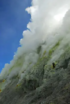
Welirang means "sulphur" in Javanese. As at Ijen, miners have for decades extracted the sulphur that forms around the fumaroles of Kawah Jero, broken it up and carried it down in sacks, on their backs or on small carts, along the cobbled track to Tretes. They live for several days at a time in the huts of Pondokan, at 2,450 m. Their numbers have fallen sharply. Their track has become the most used hiking route on the massif.
Arjuna, Semar and the temples of the mountain
The massif takes its name from Arjuna, the archer hero of the Mahabharata, the Indian epic adopted by Javanese culture. According to a local legend, Arjuna meditated at the summit so intensely that the mountain rose towards the sky, to the point of worrying the gods. They sent Semar, the wise servant-god of Javanese puppetry, to pull him out of his trance.
Long before hikers, the slopes of Arjuno and its neighbour Penanggungan were sacred mountains. Under the Majapahit kingdom, hermits built terraces, shrines and bathing pools there. Many are still visible on the Purwosari route. The summit, Ogal-Agil, is itself a place of prayer.
The history of the climb
The first to climb Arjuno and Welirang left no names: they were the hermits and pilgrims of the Hindu-Buddhist era, then the sulphur miners. Dutch naturalists of the 19th century, including Franz Wilhelm Junghuhn, visited the massif and described Welirang's solfataras.
In colonial times Tretes became a hill station where Surabaya families escaped the heat; the miners' track then also served day-trippers. In the 20th century Arjuno joined the list of Java's "seven summits" above 3,000 m collected by Indonesian student clubs. The massif has been protected since 1992 within Tahura Raden Soerjo, a protected forest managed by the province of East Java.
The volcano: how the massif works
Arjuno and Welirang form the two ends of a 6 km line of cones and craters oriented north-west to south-east. The massif almost entirely covers an older volcano, Gunung Ringgit, whose summit lies 3 km north-east of the main ridge. Scoria cones dot Welirang's north flank and an east-west line crosses Arjuno's south flank.
Arjuno, to the south-east, is considered dormant: its slopes are forested and its summit is a chaos of lava blocks. Welirang, to the north-west, is the only active centre: its fumaroles and solfataras, at several hundred degrees, deposit sulphur continuously. The Kembar peaks between the two also have sulphur vents and small craters.
The eruptions
Arjuno-Welirang is one of the calmest volcanoes in the region. The Smithsonian records only three episodes:
- October 1950: explosions on Welirang's north-west flank, between 2,500 and 2,700 m (VEI 2);
- August 1952: an eruption at Kawah Plupuh, on the north-west flank, with lahars and possibly phreatic explosions;
- September 1991: a possible eruption at the summit of Welirang, unconfirmed.
The PVMBG monitors the massif and publishes its activity every day on MAGMA Indonesia. The report of 15 November 2026 notes no visible plume and only two tectonic earthquakes.
Full timeline: 3 recorded eruptions
| Start | End | VEI | Location |
|---|---|---|---|
| 1991-09-13 (uncertain) | ? | – | Gunung Welirang |
| 1952-08-15 | ? | 0 | NW flank (Kawah Plupuh) |
| 1950-10-30 | ? | 2 | NW part of Gunung Welirang (2500 & 2700 m) |
Source: Smithsonian Institution, Global Volcanism Program. VEI = Volcanic Explosivity Index, from 0 (effusive) to 8 (supervolcano); each step means ten times more material.
Around the massif
- Penanggungan, the perfect temple-covered cone to the north: see the guide.
- The Cangar hot springs, at the foot of the south-west route.
- Batu, a highland town of apple orchards.
- Tretes and the Kakek Bodo and Putuk Truno waterfalls.
- Semeru and Bromo, two hours away: our base in Tumpang lies between the two massifs.
Frequently asked questions
Arjuno or Welirang?
Welirang is shorter and more "volcanic", with its fumaroles, sulphur and miners. Arjuno is higher, longer, wilder, and has the best panorama. The three-day traverse does both.
Is Arjuno-Welirang open?
The volcano is at normal level, but the Tahura often closes the massif: rainy season and fires. It has been closed since 17 October 2026 because of fires. Today's status is in the box.
How many days does it take?
Two days for one summit, three for both. From Cangar, one summit can be done in two days with less ascent.
How much does the trek cost?
The entrance fee is 200,000 IDR (≈ 10 €) per day for a foreigner. With us, Welirang starts at 2,550,000 IDR (≈ 128 €) and the traverse at 3,350,000 IDR (≈ 168 €) per person, depending on group size.
Do I need a guide?
For Welirang via Tretes, the track is obvious. For Arjuno, the Kembar traverse and the Cangar, Purwosari and Lawang routes, yes: the trails cross, are unmarked, and fog comes down fast.
Is there water on the way?
On the Tretes route, a good spring at Kokopan (1,650 m). Beyond that, very little. Bring water for the summit.
Is the massif dangerous?
The volcano is calm. The hazards are getting lost, the cold, gas near the Welirang crater and fires at the end of the dry season.
Can you visit the temples without going to the summit?
Yes. The first sites on the Purwosari route are a few hours' walk away. With a local guide you can do a day loop.
Why so few foreigners?
Because Arjuno has neither Bromo's crater nor Ijen's flames, and because it is missing from most itineraries. That is exactly why we love it.
Sources
- MAGMA Indonesia (PVMBG), Arjuno-Welirang activity report of 15 November 2026
- Smithsonian Institution, Global Volcanism Program, Arjuno-Welirang (263290)
- UPT Tahura Raden Soerjo; press: Suara Surabaya (reopening and fees, May 2026), Times Indonesia (new rules), Malang Post (online booking), CNN Indonesia and Metro TV (October 2026 closure)
- Our own treks on the massif
Article updated on 16 November 2026