Why Kawah Ijen
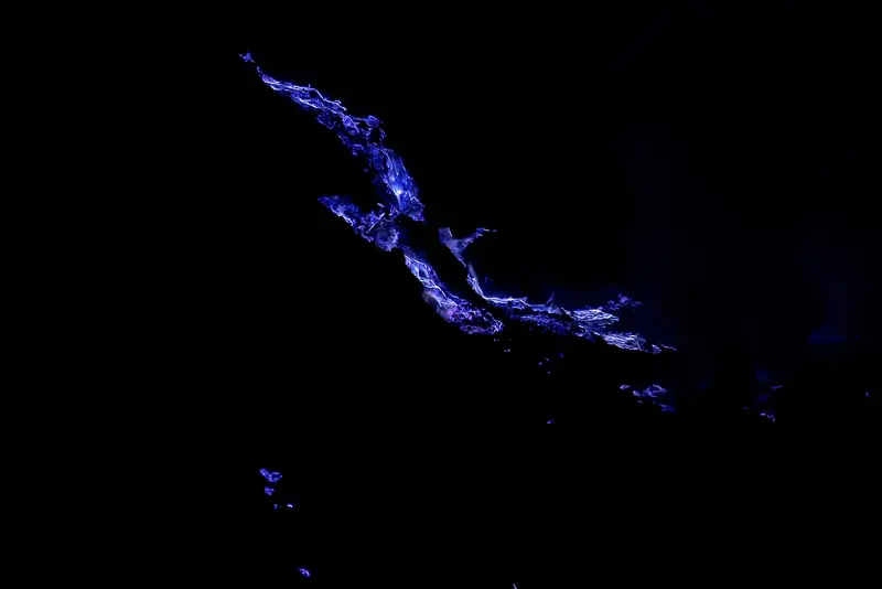
It is two in the morning at 2,300 metres. You have been walking by head torch for an hour and a half, you reach the rim of an invisible crater, and suddenly, somewhere below in the darkness, blue flames lick the rock. They are not lava flames: it is sulphur burning. The phenomenon exists elsewhere, but nowhere on this scale or so accessible.
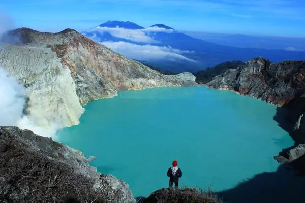
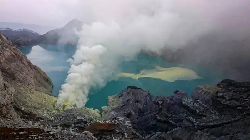
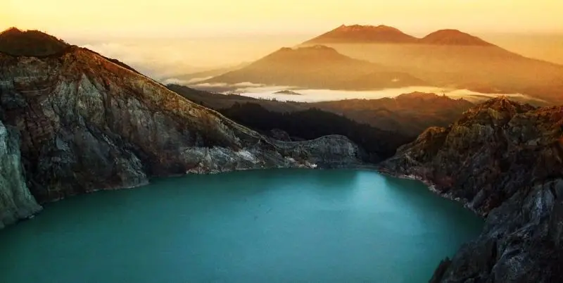
Then day breaks, and the crater reveals Ijen's other wonder: a turquoise lake a kilometre wide, the largest highly acidic lake in the world, lying at the bottom of a cauldron of grey and yellow walls, from which a thick white plume rises. The contrast of colours looks retouched. It is not.
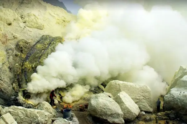
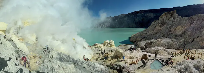
And there are the people. For more than half a century miners have gone down to the bottom of the crater for the solidified sulphur, broken it with an iron bar in the fumes and carried it up in two bamboo baskets weighing 70 to 90 kilos, before hauling it three kilometres to the scales. Passing them on the trail puts any notion of effort into perspective.
Ijen is climbed in one night, with no special training, and combines easily with Bromo and Bali. It is the ideal gateway to the volcanoes of Java.
Kawah Ijen at a glance
| Elevation | 2,386 m at the crater rim; the highest point of the complex, Gunung Merapi, reaches 2,769 m |
|---|---|
| Type | Active crater in the 20 km-wide Ijen (or Kendeng) caldera |
| The lake | About 1 km wide, nearly 200 m deep, pH below 1 |
| The blue fire | Burning sulphurous gas, visible only at night |
| Manager | Balai Besar KSDA Jawa Timur (Kawah Ijen Nature Recreation Park) |
| Trailhead | Paltuding, about 1,850 m |
| Distance | 3 km to the rim, then 800 m down to the floor (when allowed) |
| Time | 1 h 30 to 2 h up, 4 to 5 h there and back in all |
| Difficulty | Easy to moderate; the descent to the crater floor is steep and exposed to gas |
Is Ijen open today?
The box next to this article gives today's status, with its source and date. The context:
- Alert level: Ijen is at level I (normal). The MAGMA report of 14 November 2026 notes a white plume of 50 to 100 m and warns of rockfalls from the crater walls.
- PVMBG recommendations: do not go down to the crater floor or approach it, do not camp within 500 m, beware of toxic gases and CO2 emissions along the Banyupahit river.
- 2026 closures: the site was closed from 4 to 28 September 2026 after a forest fire on the massif. It had also been closed in February 2026 because of toxic gas and rockfalls, while the volcano was at normal level.
- Monthly closure: the site closes one day a month, usually the first Friday, for the Ijen Rijik clean-up programme. The dates announced for late 2026 are 6 November and 4 December.
When to go to Kawah Ijen
Ijen is open all year, apart from occasional closures.
- April to October: dry season, clear skies, the best period. July–August is high season: there can be several hundred people on the trail at 2 am.
- November to March: frequent rain, muddy trail, plume often blown down by the wind. But far fewer people.
- Time: the Paltuding ticket office opens around 1 am. The blue fire is visible until about 4:30 or 5 am; sunrise is around 5:15. The site closes in late morning: the gas becomes more troublesome as it warms up.
It is cold on the crater rim before dawn: 5 to 10 °C, with wind.
Getting to Kawah Ijen
Ijen lies at the eastern tip of Java, an hour from Bali. The trailhead is at Paltuding, reached from Banyuwangi (to the east) or Bondowoso (to the west).
From Banyuwangi
The simplest access. Banyuwangi, the easternmost city in Java, is 1 h – 1 h 30 by road from Paltuding, on a road in good condition but very steep near the end. A car with driver costs about 550,000 IDR (≈ 28 €) return. You leave the hotel around half past midnight or one.
You reach Banyuwangi:
- from Bali: ferry from Gilimanuk to Ketapang, every 15 to 30 minutes, about an hour's crossing, 7,500 IDR (≈ 0 €) for a foot passenger;
- by train from Malang, Probolinggo or Surabaya (Banyuwangi Kota and Ketapang stations);
- by plane: Banyuwangi airport (Blimbingsari) has flights to Jakarta and Surabaya.
From Bondowoso and the Ijen plateau
From the west, the road crosses the Ijen plateau, covered in colonial arabica coffee plantations (Kalisat, Jampit, Blawan), with hot springs and waterfalls. You can sleep in old planters' houses there, 30 to 45 minutes from Paltuding. It is the logical access if you come from Bromo by road, or continue to Raung.
The climb, step by step
Paltuding, the base camp
Paltuding is a large car park in the forest, with the ticket office, warungs and toilets. You buy or show your ticket there, rent a gas mask (about 50,000 IDR (≈ 3 €)) and, if you wish, find a local guide (about 150,000 IDR (≈ 8 €) per group).
The climb to the crater rim
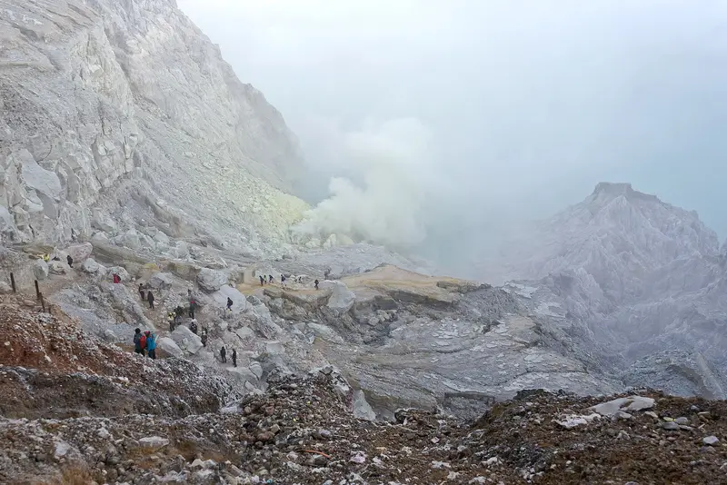
The wide, packed trail climbs 3 km at a steady gradient, quite steep in the first third. You pass Pondok Bunder (2,214 m), the post where the miners weigh their sulphur. Allow 1 h 30 to 2 h at your own pace. Miners offer "taxis": three-wheeled carts they pull uphill and hold back downhill. It has become a bigger income for them than sulphur.
The descent to the crater floor (when allowed)
From the rim, a narrow rocky path drops about 200 m in 30 to 45 minutes to the sulphur vents on the lake shore. That is where you see the blue fire up close, and the miners at work in the fumes. A gas mask is essential: when the wind turns, the sulphur dioxide plume wraps around you and makes breathing hard within seconds. Always give way to loaded porters. This descent is forbidden when the PVMBG or the manager closes it, which is frequent.
Sunrise over the lake
Climb back to the rim before 5 am and follow the ridge south-west to the high point at about 2,400 m. From there you watch the lake light up, the plume rise, and in the distance Raung and, on clear days, Bali's Agung volcano. Do not lean over the drop for a photo: tourists have fallen, including a Chinese visitor in 2024.
The descent to Paltuding
An hour on the same trail, with views of the forest and Ijen's Merapi that you did not see on the way up.
The blue fire: where does it come from?
It is not blue lava. At the bottom of the crater, cracks release sulphurous gas at several hundred degrees. On contact with air it ignites and burns with an electric-blue flame, like a gas stove. Part of the sulphur condenses into liquid, which runs in burning streams before solidifying into a lemon-yellow mass. The flames are only visible in the dark; in daylight they are there but invisible.
The phenomenon was popularised worldwide in the early 2010s by the photographs of the Frenchman Olivier Grunewald. Before that, Ijen was known mainly for its miners.
The sulphur miners
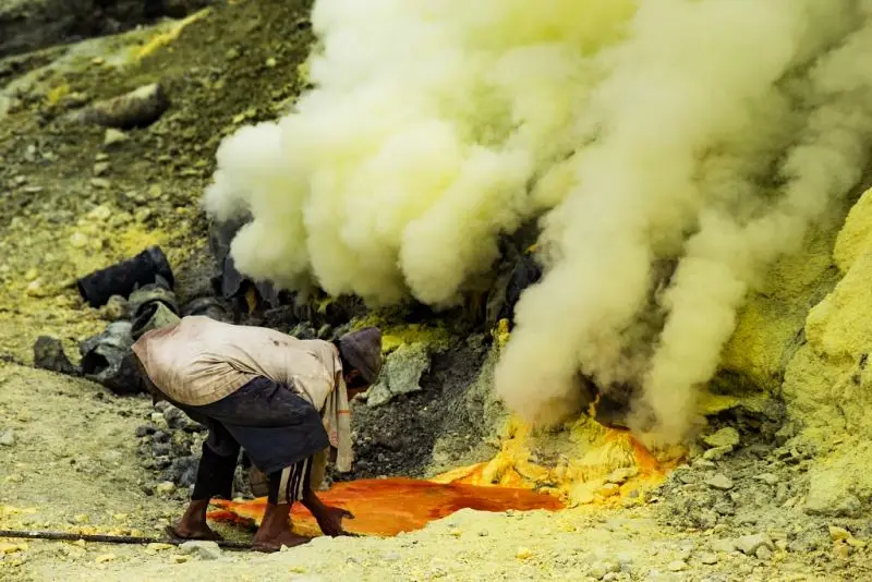
A company has mined Ijen's sulphur since 1968. To channel the gas, ceramic pipes were laid over the vents: the sulphur comes out liquid, at more than 100 °C, and solidifies in the air. The miners break it into blocks and carry it up on their backs: 200 m of ascent in the smoke, then three kilometres to the scales at Pondok Bunder. They are paid by the kilo. The sulphur is used mainly to bleach cane sugar and in the chemical industry.
There were several hundred of them in the 2000s; there are far fewer today, many having turned their baskets into carts for tourists. Their health is permanently damaged by breathing sulphur dioxide. If you want to help them, buy their small sulphur carvings, pay fairly for the carts, and do not photograph them without asking.
1976: the accident that founded the miners' ritual
In 1976, a gas release at the bottom of the crater killed miners. The figures differ between accounts: 4 dead and 17 miners who passed out according to testimony gathered from the miners, 11 dead according to The Jakarta Post, which speaks of a "giant gas bubble" rising from the lake, and 49 dead on many amateur volcanology websites, often with a second accident of 25 dead in 1989. These two high tolls appear neither in the Smithsonian catalogue nor in the scientific review by Caudron and colleagues, which lists Ijen's activity since 1770: they probably come from oral tradition.
What is certain is the mark the accident left. Since 1976, every December, the miners hold a protection ceremony (selamatan): prayer, a sacrificed goat, a shared meal, and the animal's head buried the next morning near the sulphur vents. According to tradition, a miner received the instruction in a dream.
The danger is real. In March 2018, a gas release from the lake (CO₂ and H₂S) poisoned about thirty residents of the hamlet of Watucapil, downstream, and closed the crater. Recent research shows that the lake's "quiet" years are the ones in which gas builds up.
The most acidic lake in the world
The Kawah Ijen lake holds tens of millions of cubic metres of water laden with sulphuric and hydrochloric acid, with a pH below 0.5. It is the largest lake of its kind on Earth. Its turquoise colour comes from the high concentration of dissolved metals and from light scattered by fine suspended particles. Its temperature is around 30 to 40 °C.
The lake seeps west into the Banyupahit river ("bitter water"), which acidifies irrigation water as far as the Asembagus plain, more than 40 km away. In 1921 the Dutch built a dam on the west wall to regulate the lake level and limit lahars in case of eruption.
Do not touch the water and stay away from the shore: in a phreatic eruption the lake can be thrown out, and gas bubbles can suddenly rise to the surface.
How much does Ijen cost?
The entrance fee
For a foreign visitor, entry to the Kawah Ijen Nature Recreation Park costs 150,000 IDR (≈ 8 €) per person, on weekdays and weekends alike. Payment is cashless (QRIS) or online.
The rest
| Item | Indicative price |
|---|---|
| Car with driver Banyuwangi → Paltuding → Banyuwangi | 550,000 IDR (≈ 28 €) |
| Gas mask rental | 50,000 IDR (≈ 3 €) |
| Local guide at Paltuding (per group) | 150,000 IDR (≈ 8 €) |
With Terre des Volcans
Our Ijen trip from Banyuwangi, with private car, mask and torch, starts at 110,000 IDR (≈ 6 €) per person for a full group. But most of our travellers do Ijen as part of a tour.
Our Ijen trips
Kawah Ijen by night
The crater, the acid lake and, when allowed, the blue flames. Round trip from Banyuwangi.
- 1 day(s)
- ●●●●● Easy
- Start : Banyuwangi
- Can depart any day · max. 5 people
from 110,000 IDR ≈ 6 € per person
Itinerary
- Day 1 — Kawah Ijen by night
Leave around 1:00, 1.5 hours by road to Paltuding. A 3 km climb to the crater rim (2,386 m), down towards the blue flames if the authorities allow it that day, sunrise over the acid lake. Ends in Banyuwangi or at Ketapang harbour (ferry to Bali).
Departures
- Banyuwangi — 01:00
| Group size | Price per person | Approx. |
|---|---|---|
| 1 person (solo) | 550,000 IDR | ≈ 28 € |
| 2 people | 275,000 IDR | ≈ 14 € |
| 3 people | 185,000 IDR | ≈ 9 € |
| 4 people | 140,000 IDR | ≈ 7 € |
| 5 people | 110,000 IDR | ≈ 6 € |
Entrance fees to add: Kawah Ijen : 150,000 IDR (≈ 8 €) per day, per person × 1.
Included
- Air-conditioned car with driver
- Gas mask and headlamp (on loan)
- Packed breakfast
Not included
- Park entrance fees (amount shown above)
- Local guide on Ijen (can be booked on request)
- Tips
- Travel and evacuation insurance
Options
- French-speaking guide (subject to availability) — on request
Combine it in a tour
Bromo – Kawah Ijen
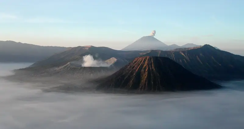
East Java's two classics in three days, from Malang to the Bali ferry, without a single wasted hour on the road.
from 3,200,000 IDR ≈ 160 €
Semeru – Bromo – Kawah Ijen
The great East Java traverse: three active volcanoes in four days, from Malang to the doorstep of Bali.
from 5,500,000 IDR ≈ 275 €
Kawah Ijen – Raung
The volcano everyone visits, then the one nobody climbs. Three days from Banyuwangi.
from 4,650,000 IDR ≈ 233 €
What to bring
- A cartridge gas mask (not a surgical mask): provided by us, otherwise rent one at Paltuding
- Head torch: the trail is not lit
- Warm clothes for waiting on the crater rim: 5 to 10 °C and wind
- Closed shoes with good soles: the descent into the crater is rocky and slippery
- Glasses: the gas stings the eyes, and contact lenses quickly become unbearable
- Water and snacks
Who should not go down into the crater
Ijen's gases are no legend. Asthmatics, people with respiratory or heart conditions, pregnant women and young children: stay on the crater rim. The sunrise is just as beautiful there, and the air is breathable.
The history of Ijen
The Ijen plateau was long an almost empty forest on the border between the kingdoms of Blambangan and Bali. In the 18th century the Dutch took an interest in it for sulphur and land. The naturalist Franz Wilhelm Junghuhn explored the crater in the 1840s and drew maps and sketches of it. In the early 20th century the colonial administration set up arabica coffee plantations on the plateau (Kalisat, Jampit, Blawan), which still produce a renowned coffee today.
The 1921 dam, industrial sulphur mining from 1968, then the arrival of hikers in the 1990s transformed the crater. Tourism boomed after 2010, with the photos of the blue fire and the rise of tours from Bali. In 2023 the Ijen Geopark was recognised as a UNESCO Global Geopark for the geological value of the caldera and its volcanoes.
The volcano: the Ijen caldera
Kawah Ijen is only a small part of a huge whole: the Ijen caldera (or Kendeng), 20 km across, formed by the collapse of an old giant volcano about 50,000 years ago. Its northern wall still forms a clearly visible arc-shaped ridge; elsewhere it has been buried by younger volcanoes, including Gunung Merapi (2,769 m, not to be confused with Central Java's Merapi), the highest point of the complex, and Raung on the south-west rim.
Kawah Ijen is an active crater just west of Merapi. Its activity is mainly hydrothermal: the acid lake is heated and fed by magmatic gases. Eruptions are phreatic or phreatomagmatic: lake water and gas explode together, throwing out acid mud and blocks, and can trigger acid lahars to the west.
The eruptions of Ijen
The Smithsonian records 11 eruptions of Kawah Ijen, the oldest dated to around 640 BCE.
1796. The first eruption noted by Europeans.
January 1817. The strongest historical eruption: part of the lake was thrown out, acid lahars devastated the plain to the west as far as Bondowoso. Neighbouring Raung erupted the same month.
1917, 1936, 1952. Moderate phreatic eruptions. That of 1936 threw mud up to the crater rim.
1993-1994. After weeks of earthquakes and tremor, the lake temperature rose from 30 to 41 °C and the water turned whitish and boiled: the volcanologist banned access within 3 km. Phreatic explosions followed in July 1993 and February 1994.
1999 and 2000-2002. Small phreatic eruptions and bubbling of the lake, with temporary closures.
Since 2012. Several spells at level II because of rising gas and lake temperature, then back to level I. In 2026 the crater is calm but the authorities stress toxic gas and rockfalls.
Full timeline: 11 recorded eruptions
| Start | End | VEI | Location |
|---|---|---|---|
| 2002-07-29 (uncertain) | 2002-08-15 | 1 | Kawah Ijen |
| 2000-09-01 (uncertain) | 2000-09-10 | 1 | Kawah Ijen |
| 1999-06-28 | 1999-06-28 | 1 | Kawah Ijen |
| 1994-02-03 | 1994-02-03 | 1 | Kawah Ijen |
| 1993-07-03 | 1993-08-01 | 1 | Kawah Ijen |
| 1952-04-22 | 1952-04-24 | 1 | Kawah Ijen |
| 1936-11-05 | 1936-11-25 | 2 | Kawah Ijen |
| 1917-02-25 | 1917-03-14 | 1 | Kawah Ijen |
| 1817-01-15 | 1817-02-18 | 2 | Kawah Ijen |
| 1796 | ? | 2 | Kawah Ijen |
| 640 BCE | ? | – | Kawah Ijen |
Source: Smithsonian Institution, Global Volcanism Program. VEI = Volcanic Explosivity Index, from 0 (effusive) to 8 (supervolcano); each step means ten times more material.
How Ijen is monitored
The PVMBG observatory near Licin continuously tracks seismicity, lake temperature and colour, and gases. The reports published on MAGMA Indonesia are the reference. The one of 14 November 2026 counts one gas explosion and three episodes of tremor in 24 hours, and maintains the bans on the crater floor.
Around Ijen
- Raung, on the caldera rim: the largest caldera in Java, two days' walk away. See our guide.
- The plateau and its coffee plantations, with the Blawan hot springs and the Kawah Wurung waterfall.
- Kawah Wurung, an old grass-covered caldera, magnificent at sunrise.
- Baluran National Park, Java's "little Africa", an hour to the north: savannah, buffalo and deer.
- Bali, an hour away by ferry.
Frequently asked questions
Can you see the blue fire in 2026?
Only at night, and only when the descent to the crater floor is allowed, which is not the case in November 2026: the PVMBG advises against going down. From the rim you sometimes glimpse a distant blue glow. We never promise the blue fire.
What is the entrance fee for Ijen?
150,000 IDR (≈ 8 €) per person for a foreign visitor, every day of the week, payable cashless.
What time should you leave?
Around 12:30 – 1 am from Banyuwangi, to start walking around 1:30 – 2 am at Paltuding. You will be on the crater rim between 3 and 4 am, before sunrise.
Is the Ijen climb difficult?
No. Three kilometres on a wide trail, 500 m of ascent, 1 h 30 to 2 h up. Anyone in good health can do it. The descent to the crater floor, when open, is steeper and exposed to gas.
Do you need a guide for Ijen?
The trail to the rim does not require a guide. To go down into the crater a local guide is strongly recommended, and the authorities encourage using licensed guides. They know where to stand according to the wind.
Is a gas mask really necessary?
At the crater floor, yes, absolutely. On the rim it is useful when the wind blows the plume down. A surgical mask is useless against sulphur dioxide.
Can you do Ijen from Bali?
Yes. Ferry from Gilimanuk to Ketapang in the evening, night in Banyuwangi, climb, back to Bali by late morning. Or continue west to Bromo.
Can you swim in the lake?
No, never. It is acid: the pH is below 0.5.
Is Ijen dangerous?
The real dangers are the gas at the crater floor, falls from the rim and rockfalls from the walls. Phreatic eruptions are rare but unpredictable. If you follow the PVMBG's and your guide's instructions, the risk is low.
Can you do Ijen with children?
To the crater rim, yes, from age 6 or 7 for a child used to walking, with warm clothes. No descent to the floor for children.
Bromo or Ijen, if I can only do one?
Bromo for the grand landscapes and the caldera; Ijen for the strangeness, the colours and the miners. In reality they are half a day apart by train, and our Bromo – Kawah Ijen tour does both in three days.
Sources
- MAGMA Indonesia (PVMBG), Ijen activity report of 14 November 2026
- Smithsonian Institution, Global Volcanism Program, Ijen (263350)
- Balai Besar KSDA Jawa Timur; Ministry of Forestry, Kawah Ijen Nature Park page
- Indonesian press: Detik (fees) and Times Indonesia (fees), Katadata (closure after the fire), Jawa Pos (reopening on 28 September 2026), Beritajatim (February 2026 closure)
- The 1976 accident and the miners' ritual: Al Jazeera ("In pictures: Mining sulphur in Indonesia", 2014), Dodho Magazine (Gembong Nusantara), The Jakarta Post ("Trapped under yellow yoke", 6 October 2013), vulkane.net; Geoscopy, on the accident's absence from the review by Caudron et al.
- The March 2018 gas release: Ministry of Energy and Mineral Resources (ESDM), Tanggapan kejadian gas beracun di Kampung Watucapil; The Jakarta Post, 22 March 2018
- Our own climbs of Ijen since 2017
Article updated on 16 November 2026